Geography
Köln is found in the Northeast German Province of Westphalia, on the west bank of the Rhine River. The river leads to the North Sea, and seafaring vessels can navigate to Köln. It is situated on the southern side of the North German Plain, which has fertile soil for farming. Hills surround Köln on the East and West, and the Rhine Valley lies to the south. The weather is generally temperate, ranging between 2 °C and 18 °C, but was generally poorer in the Middle Ages, with frequent flooding. [1]
Roman Founding
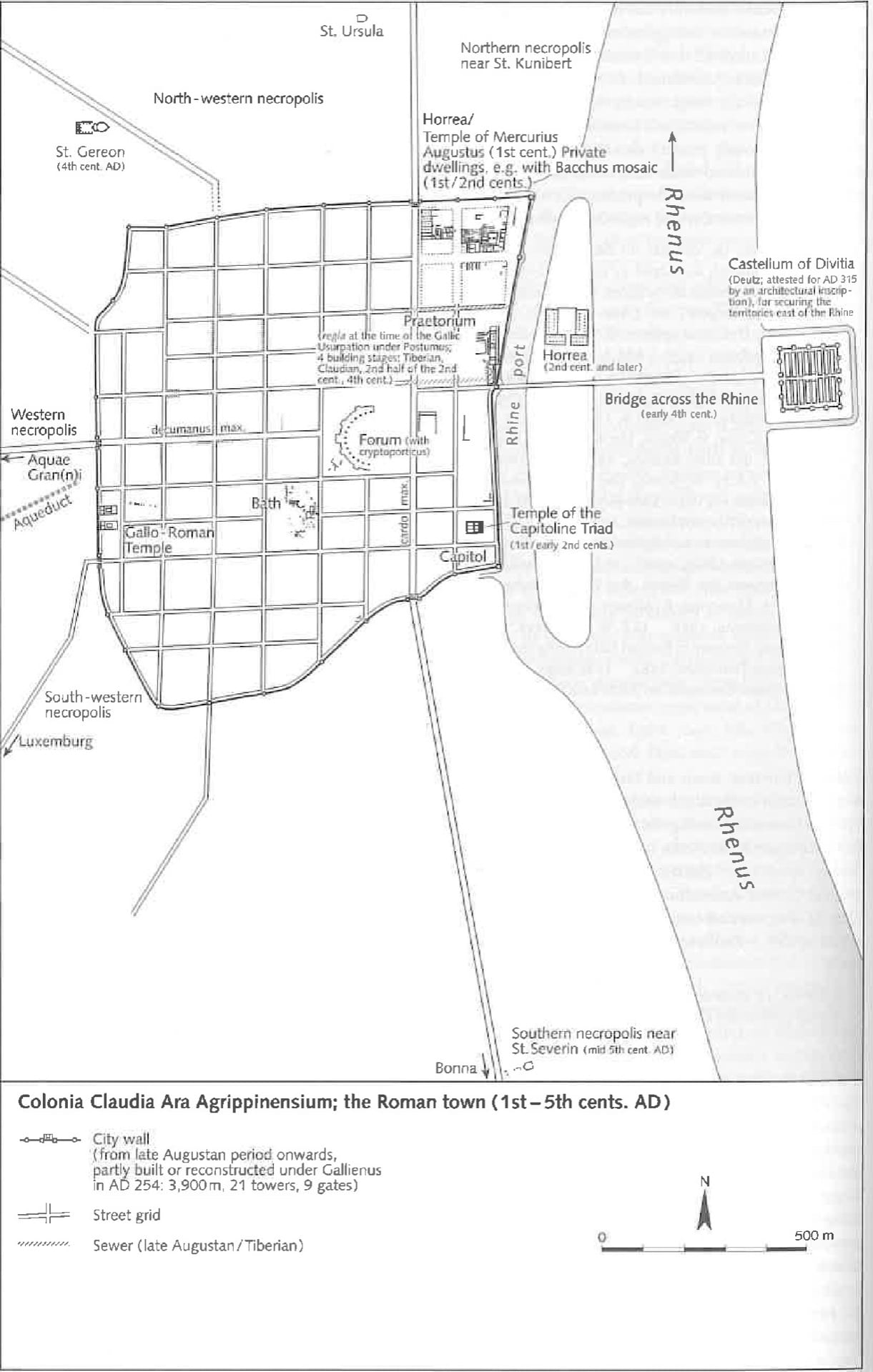
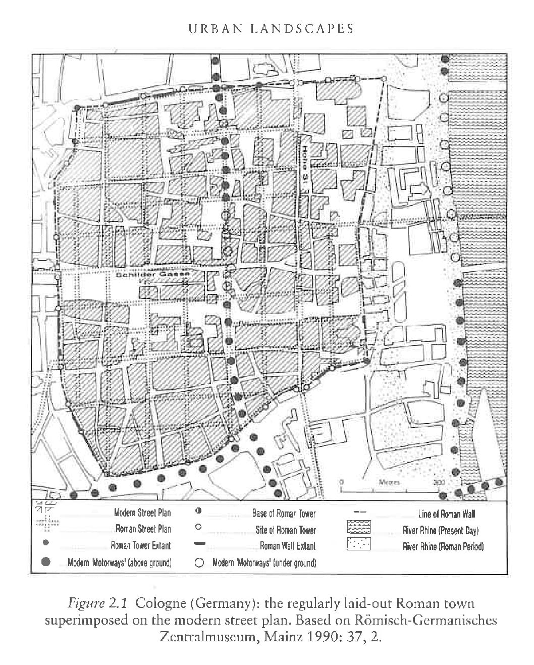
Köln was founded as a Roman settlement in 38 B.C.E, as a support for two legionary camps nearby. It was officially made a colony in 50 C.E by Empress Agrippa, gaining the name Colonia Claudia Ara Agrippinensium. It was at this point that the first city wall was built. [2] The city was built in a typical Roman style, with a central forum with temples, and later churches, villas, sewers, and markets, all built within a square grid bounded by the walls. This was the stronghold of the city, or the “urb,” and would have held approximately 15,000 people. [3] The area outside of the city would have been scattered villas, farms, and outposts, known as the “suburbium,” which would have been home to 5,000 people. [4] The Franks kept the street plan when they occupied the city, unusually for most former Roman cities in the north of Gaul. They also continued to occupy the Roman central buildings, specifically the Roman cathedral and the Governor’s house, which became the town hall. The Roman layout is still visible in the layout of the streets today, in particular the Hohe Straße, which follows the Cardo Maximus, and the Schilder Gaße, which follows the Decumanus Maximus. [6] Some parts of the walls are also still intact, and continue to define the inner city.
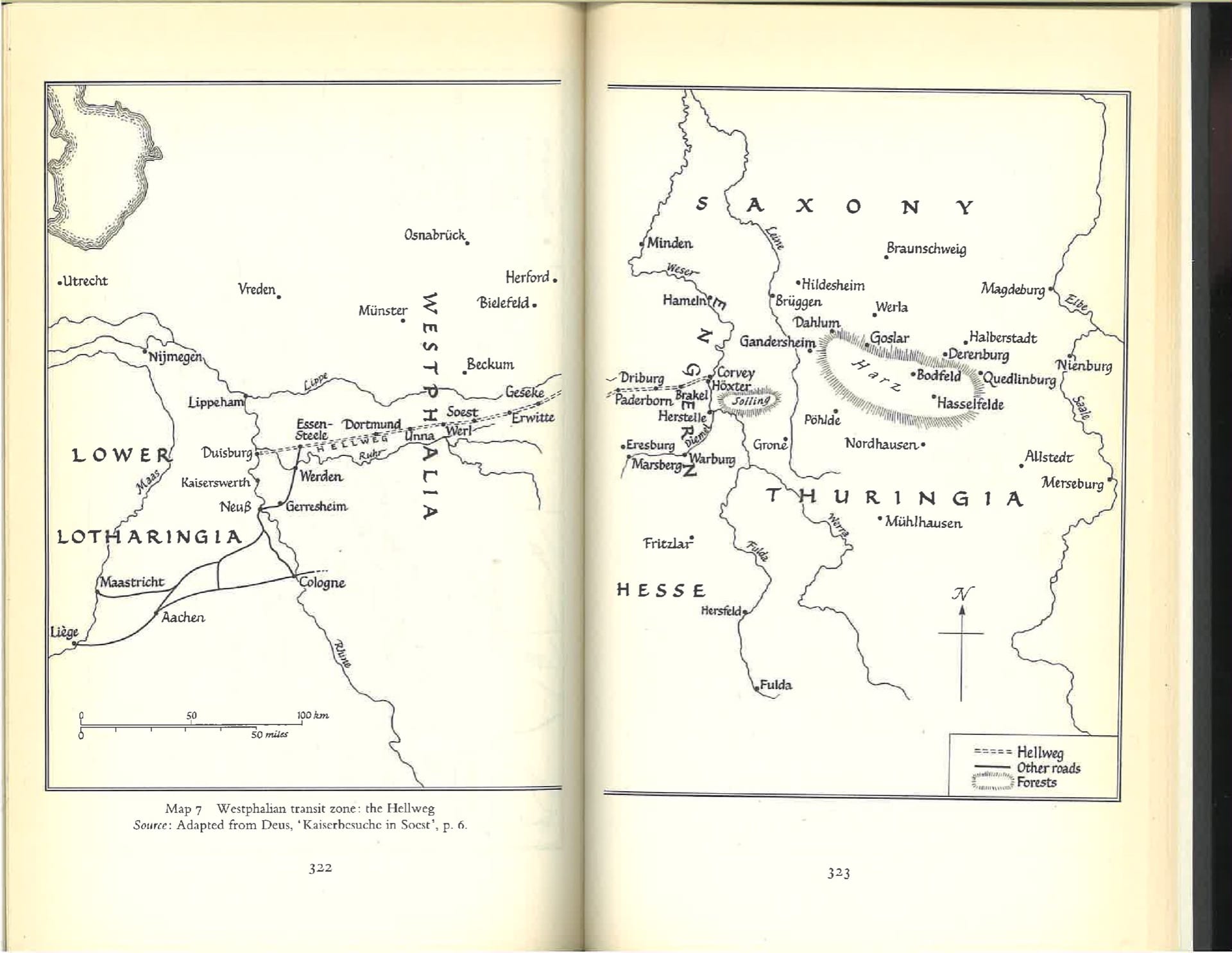
Roads of Westphalia
Expansions
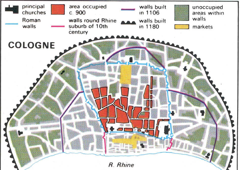
The original Roman wall did not reach all the way to the bank of the Rhine, and as the population of Köln grew, people moved into the area between the main city and the river. The merchant population was large and grew in strength leading to the construction of a Wik, a fortified merchant settle and warehouse that is occupied inconsistently as merchants travel to and from the city. In 950, walls were built connecting to the original Roman wall, providing a boundary for what would become Deutz, the earliest German walled suburb. [9]. By the twelfth century, Cologne would have thirteen distinct communities, influencing the social and political structure of the areas.
Social expansion also caused economic growth, as seen in the change and increase in the markets of Köln. Haymarket, the first of Köln’s markets, was originally placed on an island in the Rhine directly next to Köln, although it was moved inside the city in 957. Located next to the harbor, it was an ideal place for trade. Despite the presence of this large market, Köln’s growth in the 10th and 11th centuries led to three new markets being developed towards the end of the 11th century.
Another indicator of the expansion of the city of Köln is new churches being built. Köln has twelve Romanesque churches built between the fourth and the 13th century. [10] Churches, as centers of social life, both led and followed social expansion in Köln, as churches were built in areas of high population density, and as people flocked to the areas around established churches. Archbishop Bruno the Great was responsible for a few of the later churches, although most predate him. The twelve churches are listen below in order of date of consecration or build, and they are indicated on the map.
- St. Severin 4th century, extended several times
- St. Ursula Built on the ancient ruins of a Roman cemetery where 11,000 virgins and Saint Ursula are supposedly buried. (5th century)
- St. Cecilia’s (9th century)
- St. Maria im Kapitol, originally built on the foundations of a Roman temple and a church from 690, church built in the 8th century
- St. Apostein or Basilica of the Holy Apostles (9th century)
- St. Cecilia’s (9th century)
- St. Maria Lyskirchen (948)
- St. Andreas (cons. 974)
- St. Pantaleon, built over a Roman villa, the church was built in 870, and a Benedictine abbey was added in 955 by Archbishop Bruno the Great, consecrated in 980
- Great St. Martin (10th century)
- St. Georg (11th century)
- St. Kunibert (1247)

Footnotes:
1. William H. Berentsen et al., “Cologne,” Encyclopædia Britannica, November 29, 2017, , accessed March 11, 2019, https://www.britannica.com/place/Cologne-Germany.
2. Richard Stillwell, William L. MacDonald and Marian Holland McAlister, “Colonia Agrippinensis (Cologne) Germany,” in The Princeton Encyclopedia of Classical Sites. (Princeton: Princeton University Press, 1976).
3. Robert Dickinson, “THE DEVELOPMENT AND DISTRIBUTION OF THE MEDIEVAL GERMAN TOWN: 1. THE WEST GERMAN LANDS,” Geography : Journal of the Geographical Association 27, no. 1 (1942): 9.
4. “Colonia Agrippensis,” Brill’s New Pauly, Encyclopaedia of the Ancient World, ed. Hubert Cancik and Helmuth Schneider, (Boston: Brill Leiden, 2003) 542-543.
5. “Cologne,” New World Encyclopedia, http://www.newworldencyclopedia.org/entry/Cologne, (March 11, 2019)
6. Anngret Simms, “The Early Origins and Morphological Inheritance of European Towns,” in Urban Landscapes, ed. J.W.R. Whitehand and P.J. Larkham (London: Routledge, 1992) 23-26.
7. Ken Pennington, “Cologne Map Colonia Agrippa,” History 211: The Italian Renaissance: Florence, , http://legalhistorysources.com/ChurchHistory220/Lecture Seven/Cologne1300.htm.
8. John William Bernhardt, Itinerant Kingship and Royal Monasteries in Early Medieval Germany, c. 936-1075, (Cambridge: Cambridge University Press, 1993) 177-181.
9. David Nicholas, The Growth of the Medieval City, (New York: Longman, 1997) 28, 71, 382-383.
10. Joseph P. Huffman, “Cologne, Archdiocese,” in Medieval Germany : An Encyclopedia, ed. John M. Jeep (New York: Garland Pub., 2001) 135.
11. “Civitates Orbis Terrarum,” Historic Cities, , accessed March 11, 2019, http://historic-cities.huji.ac.il/mapmakers/braun_hogenberg.html#maps.

· Permalink
Here guys, its Tate from over yonder in the arts and culture section. While searching for sources, I found an online picture archive that might be of use.
http://romanhistorybooksandmore.freeservers.com/p_croutdoors.htm
Included is also a book about the development of the city of Köln, although it is in German…
· Permalink
Thank you!
· Permalink
Hey I found some interesting information about a road running through Westphalia near Köln called the Hellweld. This might lead us to some more information on the road structure.
· Permalink
I found this image recently, and thought it might help you guys. It might be useful, but I don’t have any accompanying sources which discuss it.
https://commons.wikimedia.org/wiki/File:Reconstructed_plan_of_the_Roman_city_of_Colonia_Claudia_Ara_Agrippinensium_(Cologne)_in_the_3rd-4th_century_AD,_Romisch-Germanisches_Museum,_Cologne_(14896726952).jpg
· Permalink
Fixed the map issue!